

Copper Falls State Park: A complete Northwoods guide
Copper Falls State Park near Mellen, Wisconsin is a 3,068-acre Northwoods sanctuary where tannin-stained rivers plunge through billion-year-old lava gorges, and hand-cut log buildings from the Civilian Conservation Corps still stand as working park infrastructure.
The reward is one of the most dramatic waterfall landscapes east of the Rockies — a place where families can see three named waterfalls in under a mile, swim on a spring-fed lake the same afternoon, and camp under some of Wisconsin's darkest skies.
This guide walks through every trail, every waterfall, every campsite tier, and more than 40 nearby attractions so you can plan a weekend, a long weekend, or a full Northwoods week with confidence.
Overview and location
Copper Falls State Park sits 2 miles northeast of Mellen in Ashland County, at 36764 Copper Falls Road, Mellen, WI 54546 (GPS 46.3526° N, −90.6454° W). From the Milwaukee area, plan on roughly 340 miles and 5.5 to 6 hours of driving; the most common routing is I-41/US-45 north to Antigo, then west and north through Phillips and Park Falls to Highway 13 into Mellen, turning east on WI-169 for the final 1.8 miles to the park entrance. Ashland lies 25 miles north on Lake Superior, Duluth is about 92 miles northwest, and the Michigan UP border at Hurley sits 40 miles east.
Wisconsin purchased the original 520 acres at the falls in 1929, making Copper Falls one of the state's older parks; subsequent acquisitions grew it to today's 3,068 acres. The DNR's own description is blunt and earned: "Ancient lava flows, deep gorges and spectacular waterfalls make Copper Falls State Park one of Wisconsin's most scenic parks." In 2005 the park was listed on the National Register of Historic Places with 10 contributing CCC/WPA properties, one of very few state parks to hold that distinction. The park is open 6 a.m. to 11 p.m. year-round.
What makes it special is the stack of stories layered on top of each other: a billion-year-old rift valley, a failed 1800s copper mining rush, an Ojibwe homeland that still borders the river downstream, and a Depression-era camp of 164 young men from Illinois who built nearly everything a visitor still touches today.
Waterfalls and the rivers that made them
Four named falls and more than a dozen unnamed cascades give Copper Falls its identity. The park protects 8.5 miles of the Bad River and Tyler Forks, though a half-mile section through the inner gorge is closed to the public for safety and preservation.
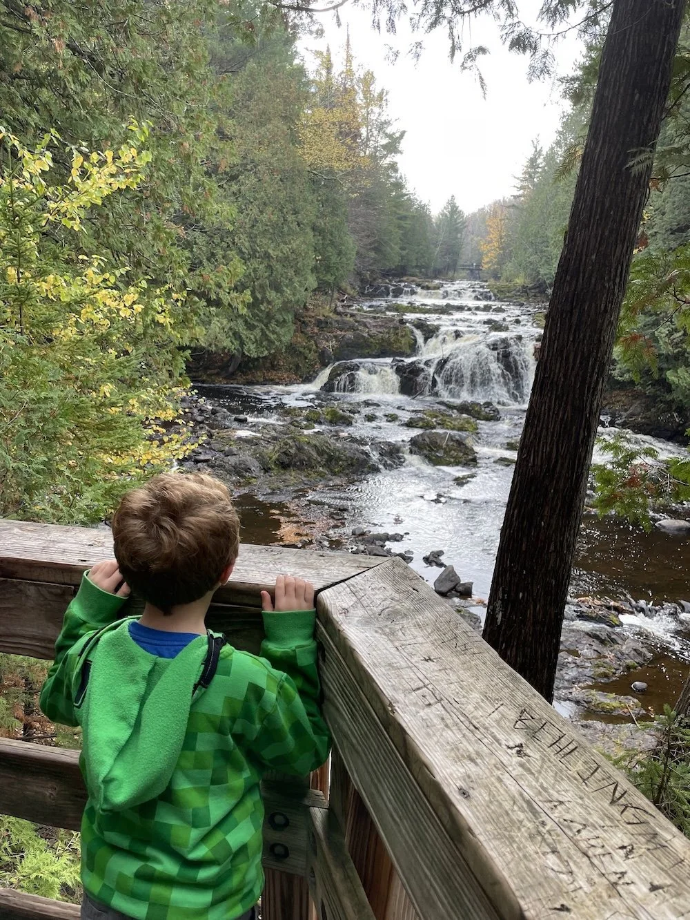
Copper Falls is the headliner — a 29-foot drop where the Bad River slides over a ledge of black basalt into the gorge. The DNR describes it as "the first drop of the Bad River as it flows through about two miles of steep-walled canyons of awesome and rugged splendor." A miner's blast in the early 1900s cracked a rock spur in the ledge, splitting the falls into twin cascades that now flank a small island of rock. Despite the name, the water is not literally copper — it's tannin-stained from peat and boreal forest drainage, giving it a dark tea-red color that, running over reddish bedrock, reads as copper to the eye.
Brownstone Falls sits a short walk downstream, where Tyler Forks plunges roughly 30 feet over a red lava (felsite) ledge directly into the Bad River gorge. It's named for the reddish-brown Chequamegon Sandstone exposed in the gorge walls, and it drops from a side canyon into the main canyon — a rare and theatrical confluence. Twin overlook decks above Brownstone Falls give families the best photograph in the park.
Tyler Forks Cascades — signed as "The Cascades" — are a long chute of rapids and step-pools on Tyler Forks just upstream of Brownstone. Water skims black basalt here before hitting the red-lava lip downstream, and the stone CCC bridge and footbridge above the cascades are among the most photogenic human-built features in the park.
Red Granite Falls lies on the Bad River in the park's less-traveled south end, reached by a 2.5-mile lollipop trail. It's a series of small falls and rapids sliding over red granite outcroppings "larger than an average home," and it's the only waterfall in the park you can legally share with a leashed dog.
Devil's Gate, 600 feet downstream of Brownstone Falls, is not a waterfall but deserves a mention alongside them: a narrow rock "gate" where the Bad River knifes between hulking abutments of Copper Harbor Conglomerate (the DNR calls it "peanut brittle-like" rock). Modern footbridge, CCC staircases, and 80-foot gorge views.
The geology in plain English
The rocks here record a 1.1-billion-year-old continental rift — the Midcontinent Rift, the same event that created the Lake Superior basin. Thousands of cubic miles of lava oozed from deep fissures, piling up to 60,000 feet thick. Sand, mud, and boulders later filled in as the basin sagged, hardening into the brown Chequamegon Sandstone, the Nonesuch Shale, and the Copper Harbor Conglomerate you can see today. Tilting faulted the layers nearly onto their edges. Over the last 200 million years the Bad River and Tyler Forks carved the gorges; within the last million years, glaciers dumped the red clay and granite boulders that cap the uplands. A few thousand years ago Lake Superior stood high enough to leave ancient beach lines inside what is now the park.
Hiking trails, trail-by-trail
The park holds roughly 17 miles of hiking trail, including a 4-plus-mile segment of the North Country National Scenic Trail. Here's what to actually walk.
Doughboys' Nature Trail (1.7 miles, easy–moderate loop) is the signature hike and, per the DNR, "one of the best hikes in Wisconsin." It starts at the concession building, crosses the Bad River on a log footbridge, and threads the gorge rim past Copper Falls, the Cascades, Brownstone Falls, Devil's Gate, and back. It's named for the World War I "doughboys" Nick Stilin and Henry Kritz, who built the first footbridges here in 1922. Expect stone stairways hand-cut by the CCC from black slate quarried in Mellen, two stout log-timber footbridges (the "big bridge" at the trailhead and the Devil's Gate footbridge, not cable suspension bridges despite some blogs), a CCC stone bridge over Tyler Forks Cascades, two concrete overlook decks above Brownstone Falls, and a wooden platform at Copper Falls. Pets are not allowed on this trail. In winter the main loop is closed due to icy stairs.
Red Granite Falls Trail (2.5-mile lollipop, easy–moderate) leaves from the Loon Lake parking area and drops to the Bad River 1.2 miles out at the falls. Wide crushed-granite tread, about 200 feet of elevation gain, river views, and a glimpse of the old iron-ore railroad bed that once hauled Penokee ore to the Ashland docks. This is the park's only trail open to leashed dogs and the only waterfall hike open with snowshoes in winter.
CCC 692 Trail (1 mile spur) climbs 142 steps built into the hillside to the 65-foot wooden observation tower originally erected in 1930. On clear days the view reaches Lake Superior, the Apostle Islands, the Penokee Range, Mt. Whittlesey (highest point in the Penokees), and the Chequamegon National Forest — though summer foliage now partly blocks the sightline, so spring and late fall are best.
North Country National Scenic Trail (roughly 4 miles in-park, up to 10.5 with connectors) runs north–south through the park, sharing tread with Doughboys' through the gorge and continuing to a primitive backpack campsite about 2 miles in on sandstone ledges above the Bad River. The Heritage Chapter of the NCTA added a significantly extended loop section in 2015.
Vahtera Trails (1.2-mile inner loop + 1.7-mile outer loop) leave from the Ballfield Lot in rolling glacial terrain — hemlock stands, an active beaver pond, northern hardwoods. Shared summer use with mountain bikers; groomed as the 3.2 km Orange classic-ski loops in winter.
Takesson Trails (1.6 and 2.5-mile options) run singletrack along the Bad River with a dramatic overlook of the 80-foot-deep gorge, a tamarack bog crossing, and beaver-pond views. Moderate, hilly, mountain-bike shared. Groomed 3.9 km Green classic-ski loops in winter.
Meadow Trail (1.5 miles, easy) from the Loon Lake parking area — a gentle wildlife loop through recovering forest and wet meadows, known for songbirds, butterflies, and deer. Groomed as the family-friendly 2.4 km Yellow skate-and-classic loops in winter.
Winter Waterfall Trail / Purple Loop (1 mile) is a cold-season-only rolled path from the Winter Waterfall Access lot that reaches both Copper and Brownstone Falls after Doughboys' closes.
Pipeline Trail / Blue Loop (7.4 km) is the park's longest ski route, with rolling meadows, beaver ponds, tamarack bog, and mature hardwoods — the most complete winter experience in the park.
The park's total mountain bike mileage is 4.2 miles across Takesson and Vahtera. The confusingly named Three Bridges Nature Trail is an older self-guided geology/history loop that overlaps the Doughboys' corridor.
Swimming at Loon Lake
The park's beach sits on Loon Lake, a 32-acre, 23-foot-deep spring-fed lake at the south end of the park — not on the Bad River, where the original 1930s bathing pond was destroyed by floods in 1941 and again in 1946. The bottom is 90% sand. Expect a 300-foot sandy beach, a shallow family-friendly drop-off, a grass lawn with picnic tables, and a paved accessible path to the water's edge. Swimming is at your own risk — no lifeguards are posted — and the swim zone is buoyed off from the electric-motor-only boating and fishing areas. Unofficial swimming season runs Memorial Day weekend through Labor Day. Carry-in kayaks, canoes, and SUPs are welcome; the park office rents four kayaks, four stand-up paddleboards, and an adaptive tandem kayak on a first-come basis during business hours.
Camping, from RV electric to backpack primitive
Copper Falls offers 55 family campsites split between two campgrounds, plus a group camp, an accessible cabin, and a backcountry site — a fuller picture than most family blogs summarize.
North Campground (32 sites) is the busier, closer-to-everything loop. 28 sites have electric hookups; 4 are non-electric. Site 7 is ADA-accessible with an accessible picnic table and fire ring across from the restrooms. Two vault toilets, multiple water spigots, no showers in this loop. It's the easiest walk to Doughboys' Trail and the concession building, and the best choice for first-time visitors.
South Campground (23 sites, all non-electric) is quieter, set in a wooded valley between two ridges. Four are walk-in tent sites about 100 yards from parking; carts are provided. The shared shower building with flush toilets and heated hot showers sits at the South Campground entrance — the only hot showers in the park — as does the free RV dump station. Two vault toilets and several water fountains serve the loop.
Group camp holds up to 40 people, tent-only, with its own parking, vault toilet, water fountain, picnic tables, fire ring, and grill.
Backpack campsite is one primitive site roughly 2 miles from the maintenance lot, on a 1.3-mile spur off the NCT, overlooking sandstone ledges above the Bad River. Fire ring and primitive latrine; no water. Pets are permitted but must not use Doughboys' to reach it.
The ADA-accessible rustic cabin in the South Campground sleeps four (plus two more in one outside tent), with paved driveway, electric lights and outlets, accessible picnic table and fire ring, and an accessible flush-toilet/shower building 200 feet away. No cooking or heaters inside, no smoking, no pets other than service animals. Reserve only through the park office at (715) 274-5123; disability documentation may be required.
Six plowed electric winter camping sites (Sites 1–6) in the North Campground stay open year-round by reservation, with a shared ballfield-lot vault toilet and no running water.
Reservations run through wisconsin.goingtocamp.com or 1-888-947-2757 (WI-PARKS); the state migrated off the old ReserveAmerica system in 2023. Sites are bookable up to 11 months in advance, with a one-time $9.65 reservation fee. Standard nightly rates run roughly $20–$30 for residents depending on electric/non-electric, with a $15/night non-resident surcharge on top. Firewood is sold at the entrance woodshed (run with the Friends of Copper Falls) and seasonally at the concession — and you may not bring outside firewood from beyond 25 miles per Wisconsin's invasive-species rules. Pets on 8-foot leashes are fine in most campsites but banned from buildings, playgrounds, beaches, the cabin, and Doughboys' Trail.
Picnic areas and historic Concession Building
The main picnic area stretches over five acres on the banks of the Bad River at the trailhead for Doughboys'. You'll find numerous tables and grills, a children's playground, a softball field, and a sand volleyball court across from North Campground. The centerpiece is the Combination Building — the CCC log concession built starting in 1936, designed by National Park Service architect Bernard H. Knobla. It houses the seasonal concession (snacks, hot food, ice cream, bagged ice, firewood, camping supplies, and Sunday pancake breakfasts in summer), flush-toilet restrooms, and a world pin map where visitors mark their hometowns. It's open daily Memorial Day through Labor Day and weekends into mid-October.
The historic log shelter with its stone fireplace is reservable through the state's day-use system up to 11 months out (not within 7 days of arrival); call the park office for exact current pricing. A dedicated pet-friendly picnic area sits adjacent to the main one, with its own tables, grills, and Bad River water access — a welcome feature since pets can't join the main waterfall loop.
Accessibility
A half-mile universal-access segment of Doughboys' Trail runs along the east side of the gorge on a firm crushed-granite surface, reaching a Copper Falls overlook, passing the historic CCC bridge over Tyler Forks Cascades, and connecting the twin Brownstone Falls decks to the wooden footbridge overlooking Copper Falls. It has its own ADA parking lot off the access road. The DNR notes all-terrain wheels or adaptive equipment may help; it's not a sidewalk-flat grade.
Beyond the trail, accessible features include Campsite 7 in North Campground, the fully accessible rustic cabin in South Campground, an accessible fishing pier on Loon Lake just west of the beach with two accessible parking spaces and a paved approach, a paved path to the Loon Lake swim beach, accessible picnic tables throughout the main picnic area, the historic log shelter, accessible vault toilets at North Campground and the ballfield, and the adaptive tandem kayak available through the office rental program. The park office restrooms have flush toilets and are accessible.
Fishing
The Bad River and Tyler Forks carry brook, brown, and rainbow trout — classified differently at different segments, so check the current WI DNR trout rules before casting. Loon Lake holds largemouth bass, northern pike, and panfish (bluegill, crappie, perch); some third-party guides list walleye but the DNR does not. The inner gorge between the concession stand, Tyler Forks bridge, and Devil's Gate bridge is closed to all visitors, including anglers, for safety. A Wisconsin fishing license is required at 16 and up; an inland trout stamp is required for the Bad River and Tyler Forks. Both are sold at GoWild.wi.gov. The Loon Lake fishing pier is your easiest family spot, and ice fishing is permitted when the lake freezes. Carry-in boat access is available at Loon Lake, electric motors only.
Winter activities
Copper Falls sits in the Lake Superior snow belt and averages around 100 inches of snow a year, and the DNR grooms a serious Nordic network: about 13.7 miles classic and 6.5 miles skate-groomed, across five color-coded loops.
Loop Length Grooming Best for Blue (Pipeline) 7.4 km Skate + classic All-levels, full experience Yellow (Meadow) 2.4 km Skate + classic Beginners, families, early season Orange (Vahtera) 3.2 km Classic only Intermediate, hemlock tunnel Green (Takesson) 3.9 km Classic only Advanced, hilly singletrack Red (Red Granite) 3.2 km Packed multi-use Snowshoe + ski, pet-friendly
Skiers 16 and older need a Wisconsin State Trail Pass ($25 annual / $5 daily) in addition to the vehicle sticker. Hikers and snowshoers do not need a trail pass. Snowshoeing is permitted on the Red Loop and off-trail everywhere except on groomed ski corridors. The 1-mile Winter Waterfall / Purple Loop is the only maintained winter route to Copper and Brownstone Falls, which build up dramatic, daily-changing ice formations through January and February. Ice fishing is active on Loon Lake (bass, pike, panfish), and the park regularly hosts candlelight ski and snowshoe nights, a guided 4-mile snowshoe to the Bad River, a 1-mile candle-lit walk on the Red Loop, and a late-winter maple-tapping demonstration.
Human history: Ojibwe, miners, and the CCC
Indigenous people have lived around these rivers for thousands of years — beginning with nomadic mastodon-hunters following retreating glaciers, through the "Old Copper" tradition (4,000–1,000 BCE) whose members worked pure copper veins into tools, to the Dakota and Ojibwe peoples present when French fur traders arrived on Lake Superior. The Bad River Band of Lake Superior Chippewa (Ojibwe/Anishinaabe) continues to hold the reservation immediately downstream; the Bad River flows off park land and through their homeland on its way to Lake Superior at Kakagon Sloughs.
The "Copper Falls" name comes from failed 1800s mining. Shafts appear on pre-1860s maps of the gorge, likely driven by Civil War demand for copper. In the 1880s two copper mines operated near the current log footbridge. By the late 1800s Ashland attorney Wells M. Ruggles and mine captain John Blix were running a four- or five-man crew, sinking a vertical shaft at the footbridge site and a near-horizontal shaft ("the cave") into the hillside behind today's picnic grounds. When the Bad River kept flooding their diggings, Ruggles dynamited rock to divert the river's channel — the reason the river now runs straight past the concession where it once curved through a quarter-mile loop. They found almost no copper. In 1907 Ruggles and the Ashland County Land Company sold 130 acres around the falls to St. Louis investors. The park and the falls take their name from those disappointments.
The CCC era defined the park you visit today. In November 1935, CCC Company D-692 moved into Camp Copper Falls (sometimes called Camp Mellen) — 164 young men, mostly from Illinois, including masons, carpenters, furniture makers, and blacksmiths fresh off building Giant City State Park downstate. Over 23 months they built the Combination Building (designed by NPS architect Bernard H. Knobla), granite fireplaces and benches, the first park office (now the Naturalist Cabin), the pump house, water and utility lines, the access roads, the log footbridges (shaped tight without gaps using a Nordic immigrant method), and the hand-cut black-slate stairways flanking Devil's Gate — the slate itself quarried by the CCC in Mellen. A 1936 drought turned the crew into a fire-suppression brigade. The camp closed in September 1937, and the WPA continued the work through 1941, completing the contact station, trails, a bathing pond, the custodian's house, playground, and park lighting at wages around 50¢ a day. The August 30, 1941 flood destroyed the bathing pond, its bathhouse, and two bridges; a June 24, 1946 flood finished the job, wrecking the swimming pond and washing away the original log footbridge, which was rebuilt in 1948. The Devil's Gate bridge stayed disconnected for 40 years until Park Superintendent Kent Goeckermann reopened the loop in November 1981. The park's 2005 National Register listing recognizes ten of these contributing structures.
Admission and fees
A Wisconsin State Park vehicle admission sticker is required. Rates effective August 19, 2025:
Vehicle 12-month pass Reduced-rate 12-month Daily Wisconsin plates $28 $15.50 $13 Out-of-state plates $50 $32.50 $16 WI resident 65+ $13 — $3
Reduced-rate 12-month passes are for additional same-household vehicles bought at the same time as a full-price pass. A $5 surcharge hits anyone who fails to pay before using the park. Passes are sold online at shop.wi.gov/dnrparkspasses, at the park office during staffed hours, at the 24-hour self-pay kiosk, or at any DNR service center. Wisconsin veterans with 70%+ service-connected disability and former POWs get free admission; all Wisconsin veterans get free admission on Veterans Day and Memorial Day weekend. There's a statewide Free Fun Weekend each June. The federal America the Beautiful Pass is not accepted at Copper Falls. A separate Trail Pass ($25 annual / $5 daily) is required for cross-country skiers, bikers, horseback riders, and inline skaters aged 16+ on designated trails; hikers don't need one.
Visitor tips from locals and regulars
When to go. Spring (April–May) delivers the loudest, biggest waterfalls from snowmelt but muddy trails, some facilities still closed, and black flies building toward their late-May to mid-June peak. Summer crowds are real — weekends fill the main parking lot by mid-morning, and Memorial Day through Labor Day is campground-reservation season. Fall color peaks mid-September through early October, earlier than most of Wisconsin because of the Lake Superior snow-belt latitude; this is the park's single busiest window. Winter is the secret season — groomed Nordic trails, ice-sculpted falls on the Purple Loop, and near-empty parking lots outside candlelight events.
Photography. Overcast days flatten contrast in the gorge and make for the best waterfall shots. Early morning gets soft side light on Copper Falls. Long exposures (¼ to 2 seconds) work from the log footbridge at Copper, the twin decks at Brownstone, and the Devil's Gate bridge. Tyler Forks Cascades is the most photogenic mid-shot in the park. Pack a polarizer for glare and a tripod for silk-water. The observation tower view is better in spring or late fall before foliage fills in.
What to bring. Sturdy closed-toe shoes with grip — many stairs, slippery when wet or icy. DEET or picaridin repellent (black flies peak May–June, mosquitoes stay through July, ticks in meadow grass May through October). Refillable water bottle (concession building has fountains). Layers for gorge microclimate. Your state park sticker, hard copy or windshield. Cell service is spotty to nonexistent throughout the park and along Highway 13 south of Mellen — download offline maps and the DNR trail map before you arrive.
Parking. Main lot fills by 9–10 a.m. on summer and fall weekends. Arrive early or use the Loon Lake and Ballfield lots and hike in. Separate accessible lot serves the universal-access segment.
Safety. Gorge walls drop 60 to 100 feet — stay behind railings with kids. Walk Doughboys' clockwise to manage the stairs. Swimming is prohibited anywhere but Loon Lake beach; the Bad River gorge has cold water and deadly currents. Pets are barred from Doughboys', the beaches, and buildings; Red Granite Falls Trail, campsites, and the pet picnic area are the dog-friendly zones.
Nearby attractions for a longer trip
The drive from Milwaukee is long enough that most families turn this into a three-to-five-day Northwoods trip. Within 100 miles of Copper Falls, there's more to see than most visitors realize.
Mellen (3 miles south) is the gateway — population ~800, with the Victorian 1896 City Hall on the National Register and the Mellen Area Historical Museum upstairs, plus basic diners, saloons, and the ATV/snowmobile scene. Ashland (25 miles north) is Wisconsin's "Historical Mural Capital" with 20+ downtown murals, the family-essential Northern Great Lakes Visitor Center (five-story observation tower, free admission, a 100-seat theater, and 1.7 miles of boardwalk), the historic Ashland Oredock remnant, and three sand-beach parks — Maslowski Beach, Kreher Park Beach, and Bay View Park — connected by the 11.5-mile paved ARTS Trail. Bayfield (50 miles north) is the gateway to the Apostle Islands: a 20-minute car ferry to Madeline Island and Big Bay State Park, the Bayfield Fruit Loop orchards (berries July–September, apples August–October), traditional fish boils at Greunke's Inn and the Old Rittenhouse Inn, and the free Bayfield Maritime Museum. Apostle Islands National Lakeshore itself offers the Meyers Beach sea caves (3.5-mile round-trip hike or kayak tour); the famous ice caves have only been safe enough to open on about 2% of winter days since 2000, so don't plan a trip around them.
Hurley (40 miles east) is "Snow Capital of Wisconsin," the Iron County seat, and a mining-town curiosity. The Iron County Historical Society Museum in the 1893 courthouse is the family-appropriate anchor; historic Silver Street has daytime heritage bars and restaurants, though the Lower Block has adult establishments parents will want to skip. Whitecap Mountain Ski Resort sits just 13 miles east of Mellen for winter alpine skiing.
Waterfalls are everywhere. Within an hour-and-a-half drive:
Morgan Falls and St. Peter's Dome (20 miles SW in Chequamegon NF) — 70–100-foot falls and a regional-view dome summit.
Potato River Falls (25 miles E, Gurney) — 90-foot double falls with staircase descent, rustic camping.
Upson Falls (30 miles E) — family-friendly 18-foot falls with a picnic area.
Foster Falls (30 miles E) — 25-foot remote falls; rough dirt road access.
Wren Falls (22 miles SE on Tyler Forks) — 30-foot falls, primitive campsite, high-clearance road.
Saxon Falls (40 miles NE) — 90-foot multi-tier on the Montreal River.
Superior Falls (45 miles NE) — 90-foot falls near the Montreal River mouth at Lake Superior.
Peterson Falls, Interstate Falls, Rainbow Falls, Kimball Park Falls — all near Hurley, good for a waterfall day-trip loop.
Amnicon Falls State Park (85 miles W) — multiple falls plus a covered footbridge.
Pattison State Park (100 miles W) — Big Manitou Falls at 165 feet is the tallest waterfall in Wisconsin and the fourth-tallest east of the Rockies; Interfalls Lake has a swimming beach and campground.
Forests and uplands. The park is bounded by the Chequamegon-Nicolet National Forest (1.5 million acres of dispersed camping, CAMBA mountain biking, and lakes), rides the west flank of the Penokee-Gogebic Range (the ancient iron ridge visible from the observation tower), and carries a segment of the 4,600-mile North Country National Scenic Trail. The Mt. Valhalla Recreation Area (55 miles NW, a former Olympic ski-jump training site) has 11.1 km of groomed Nordic trails and a wood-fire chalet. Mt. Ashwabay (50 miles north, 3 miles south of Bayfield) has 40 km of Nordic trails and hosts Big Top Chautauqua, the 900-seat canvas-tent theater whose mid-June-to-early-September concert season has hosted Johnny Cash, Willie Nelson, and Brandi Carlile — with a free Saturday Family Series designed for kids.
Food and lodging. In Mellen, try Copper Ridge, Dusty's, or the Penokee Mountain Deli; stay at the Mellen House B&B, the Cayuga Hotel, the Penokee Mountain Inn, or nearby private cabin rentals. Ashland has the lakefront Hotel Chequamegon, several chain motels (AmericInn, Super 8, Cobblestone), family restaurants (Ashland Baking Co, South Shore Brewery, Hugo's Pizza), and both Kreher and Prentice campgrounds. Bayfield is the most charming overnight — Old Rittenhouse Inn, Pinehurst Inn, Seagull Bay Motel, Winfield Inn — but book months out for Apple Festival weekend in early October. Hurley and Ironwood, Michigan (just across the river) have overflow chain motels when Bayfield and Ashland are full.
Address and contact information
Address: 36764 Copper Falls Road, Mellen, WI 54546
Phone: (715) 274-5123
Hours: 6 a.m. to 11 p.m. year-round
Reservations: wisconsin.goingtocamp.com or 1-888-947-2757
DNR Customer Service: 1-888-936-7463, 7 a.m.–10 p.m.
GPS: 46.3526° N, 90.6454° W
Why this park rewards the drive
Copper Falls earns every mile of the drive because it stacks experiences most parks offer one at a time. You can stand at the lip of a 1.1-billion-year-old lava flow, touch stonework cut by young men during the Depression, cross a log bridge rebuilt after the same flood that rewrote the river's course, and swim in a clear glacial lake — all before dinner. The waterfalls are the draw, but the real insight is how thoroughly the human layer — Ojibwe, miner, WWI veteran, CCC enrollee, WPA laborer, DNR trail crew — has been written directly into a landscape that still feels wild.
The smartest approach is a three-night minimum: one day inside the park for Doughboys' and Loon Lake, one day chasing nearby waterfalls on the Iron County loop or the Chequamegon forest, and one day on Lake Superior at Bayfield or the Apostle Islands. That rhythm matches what the park is actually built for — not a quick waterfall selfie, but a slow Northwoods week where kids learn to read a landscape over time.

Heading to Door County for the first time? This complete first-timer’s guide covers when to go, where to stay, what to eat, and the must-do stops.