

Ice Age Trail: The Ultimate Wisconsin Hiking Guide
Wisconsin's 1,200-mile Ice Age Trail is one of America's greatest hiking secrets — and the best segments are right in your backyard. Stretching from St. Croix Falls on the Minnesota border to Sturgeon Bay on the Door County peninsula, this National Scenic Trail traces the exact path where a mile-thick glacier ground to a halt some 15,000 years ago. For Milwaukee and North Shore families, the payoff is remarkable: world-class glacial scenery, observation towers with skyline views, family-friendly boardwalks, and genuine wilderness — all within a 30- to 90-minute drive. Whether your kids are toddlers in a stroller or teenagers ready for a real challenge, this guide covers everything you need to lace up and hit the yellow blazes.
The Ice Age National Scenic Trail is one of only 11 National Scenic Trails in the United States, placing it in the same elite category as the Appalachian Trail and the Pacific Crest Trail. It is also one of just two National Scenic Trails contained entirely within a single state. The trail follows the terminal moraine of the Wisconsin Glaciation — the farthest edge reached by the Laurentide Ice Sheet during the last ice age, roughly 25,000 to 11,000 years ago. That glacier covered two-thirds of modern Wisconsin under ice up to a mile thick, and when it melted, it left behind a dramatic landscape of kettles, kames, drumlins, moraines, and eskers that the trail threads together like a 1,200-mile outdoor geology museum.
The vision originated with Raymond Zillmer, a Milwaukee lawyer and mountaineer who in the 1950s imagined extending the Kettle Moraine hiking trails into a linear national park spanning hundreds of miles. Zillmer founded what is now the Ice Age Trail Alliance (IATA) in 1958. Congressman Henry S. Reuss championed the concept through Congress, and on October 3, 1980, President Jimmy Carter signed it into law as a National Scenic Trail. In a landmark development, the trail was designated as an official unit of the National Park System in December 2023 — the 426th NPS unit — unlocking new federal funding and recognition.
Today, approximately 675–700 miles of off-road, yellow-blazed trail are complete, with roughly 500 additional miles of connecting road routes linking the segments. The trail is divided into more than 100 named segments ranging from 1 to 16 miles each, passing through 30 of Wisconsin's 72 counties. Over 2.3 million people use the trail annually, generating an estimated $355 million in economic activity. The trail is managed cooperatively by the National Park Service, the Wisconsin DNR, and the IATA, with thousands of volunteers contributing over 100,000 hours annually to build and maintain the path.
The best segments near Milwaukee
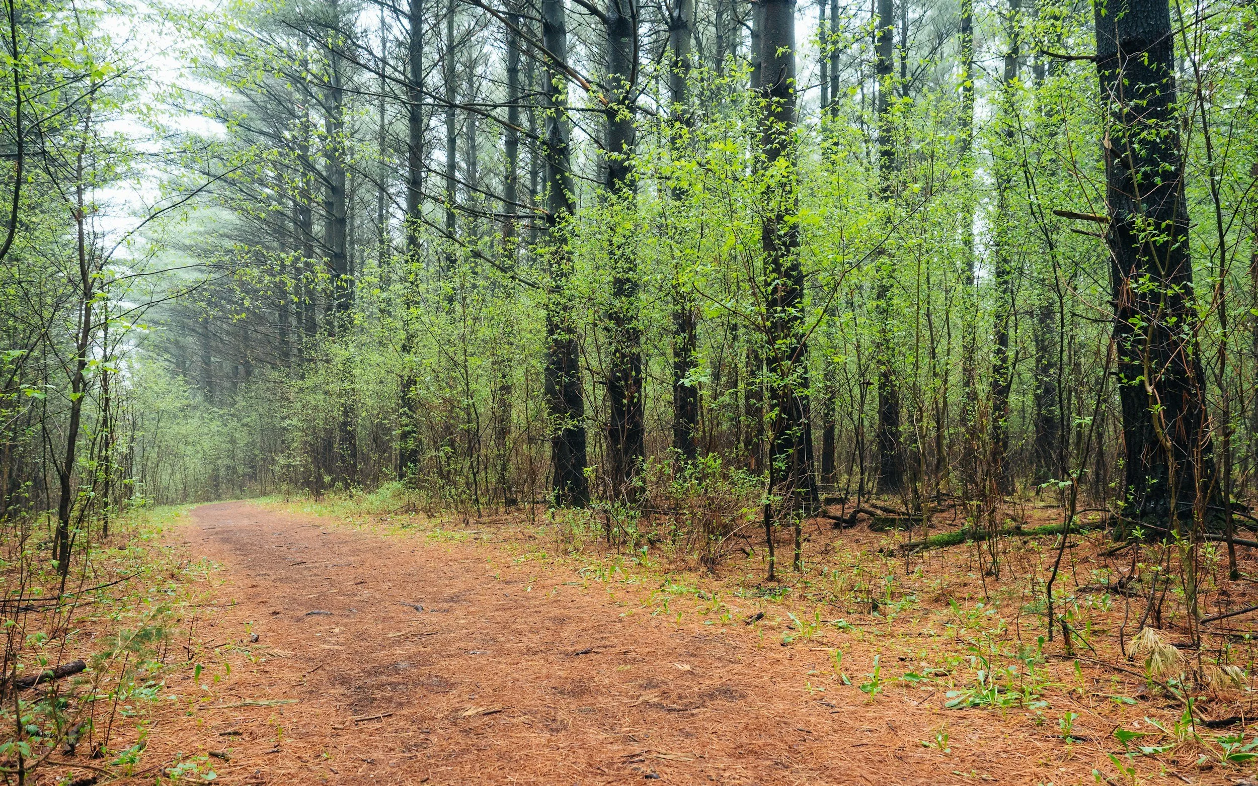
The southeastern Wisconsin segments are the crown jewels for local families. The Kettle Moraine region — a 120-mile-long ridge of glacial debris formed where the Green Bay and Lake Michigan ice lobes collided — provides the trail's most accessible and dramatic scenery. Here are the standout segments, organized by drive time from the Milwaukee North Shore.
Lapham Peak (Delafield, Waukesha County) — 30 minutes west. This is the single best starting point for Milwaukee families. The 7.8-mile Ice Age Trail segment passes through the Lapham Peak Unit of Kettle Moraine State Forest, but the real magic is the park's network of loop trails that let you customize your distance. The 1.8-mile Plantation Path is fully paved and ADA-accessible — genuinely stroller-friendly — and winds through prairie restorations and a butterfly garden. For older kids, the 3.2-mile loop to the observation tower is the signature outing: a 45-foot tower atop the highest point in Waukesha County (1,233 feet) delivers 360-degree views stretching to the Milwaukee skyline on clear days and Holy Hill to the north. Parking is at the Evergreen Grove lot off County Highway C; a Wisconsin State Park vehicle sticker ($28 resident annually, or $8 daily) is required. Critically, hunting is not allowed at Lapham Peak, making it safe for fall hiking when other segments close.
Delafield Segment — 30 minutes west. This 2.8-mile segment is essentially flat, largely paved, and follows the Veterans Memorial Riverwalk through charming downtown Delafield with views of Upper Nemahbin Lake and the Bark River. It connects to the Lake Country Recreational Trail. This is a perfect post-brunch family stroll — easy enough for preschoolers and strollers, with shops and restaurants at the turnaround.
Holy Hill Segment (Hubertus, Washington County) — 40 minutes northwest. At 6.9 miles point-to-point, the full segment is hilly and best for experienced hikers, but the scenery is extraordinary. Holy Hill Basilica perches atop a 1,350-foot glacial kame — one of the tallest in the region — with panoramic views from its spires. The trail passes through deep kettles, past glacial erratics, and through maple forests that ignite with color in late October. For families, park at the Shannon Road parking area (mid-segment, marked with a blue-blazed spur) and do a 2- to 3-mile out-and-back to capture the best scenery without the full 7-mile commitment. The Basilica grounds are worth a separate visit with kids for the views alone.
Pike Lake Segment (Hartford, Washington County) — 45 minutes northwest. This 3.3-mile segment through the Pike Lake Unit of Kettle Moraine State Forest punches above its weight. The Powder Hill observation tower sits at 1,350 feet — the second-highest point in southeastern Wisconsin — and the hike from the Black Forest Nature Trail parking lot to the tower summit is only about half a mile, making it one of the best short-hike payoffs on the entire Ice Age Trail. Pike Lake also has a swimming beach, picnic areas, and three walk-in backpack campsites, turning this into an easy overnight adventure. Trailhead parking at 3544 Kettle Moraine Road, Hartford.
Hartland Segment (Waukesha County) — 35 minutes west. A 6.8-mile segment rated very easy, featuring greenways, the Hartland Marsh boardwalk, and gentle terrain through an Ice Age Trail Community. The local chapter organizes family-specific hikes, including moonlight walks. Start at Naga-Waukee County Park.
Kettle Moraine segments worth the drive
The Northern and Southern Units of Kettle Moraine State Forest contain the densest concentration of world-class glacial features accessible from Milwaukee. These segments range from 45 to 90 minutes away and offer everything from challenging ridge hikes to easy boardwalk strolls.
Parnell Segment (Northern Unit, Fond du Lac County) — 75 minutes north. At 13.9 miles with 1,500 feet of elevation gain, this is one of the most spectacular — and most difficult — segments near Milwaukee. It features the 4-mile Parnell Esker (the trail's most notable esker), the 60-foot Parnell observation tower, and Butler Lake with its interpretive glacial displays. The full segment is too demanding for young children, but two family-accessible loops make it worthwhile: the Butler Lake Trail (3-mile loop with interpretive signs and a picnic table) and the Parnell Tower Trail (3.5-mile loop from County Highway U). Backpacking shelters #3 and #4 are located here — reserve them up to 11 months in advance, as they're extremely popular.
Eagle Segment (Southern Unit, Waukesha County) — 60 minutes southwest. This 5.3-mile segment is rated easy and is one of the best family picks on the entire trail. Frequent boardwalks cross low wetlands and prairies, including the Scuppernong Prairie State Natural Area — the largest native wet prairie east of the Mississippi. Kids will love Brady's Rocks, an 8-foot-high Niagara Escarpment dolomite outcropping that feels like a mini rock scramble. Natural springs, the Scuppernong River, and diverse wildflowers round out the experience. A water pump at the Highway 67 trailhead makes refilling easy.
Cedar Lakes–Polk Kames Segment (north of Slinger, Washington County) — 50 minutes northwest. At just 2.8 miles, this segment is perfect for families with elementary-age kids. The highlight is the Polk Kames — the second-largest cluster of kames in Wisconsin, with some towering 100 feet above the trail. Boardwalks, seasonal wildflowers (trillium, violets, jack-in-the-pulpit), and mixed forests of old oaks, sugar maple, and white birch make this a quiet gem. Parking on County Highway NN, just off I-41.
Blue Spring Lake Segment (Southern Unit, Jefferson County) — 70 minutes southwest. This 7.1-mile segment is difficult overall (1,150 feet of gain), but the Bald Bluff spur trail from County Highway H parking is a short, manageable hike to the highest point in Jefferson County with sweeping views of glacial moraines. The segment also passes the famous Stone Elephant — a massive granite glacial erratic sacred to the Prairie Potawatomi people.
How glacial geology comes alive on the trail
The Ice Age Trail is fundamentally a geology trail, and understanding what you're looking at transforms a pleasant walk into a jaw-dropping experience. Wisconsin lent its name to the entire most recent glacial period because nowhere else on Earth is the glacier's mark upon the land more impressive. Here is what your family will encounter.
Kettles are the bowl-shaped depressions that define Kettle Moraine — formed when massive ice blocks broke from the retreating glacier, were buried by sediment, and eventually melted. Many are now lakes. The Scuppernong Segment plunges into a "roller coaster" of kettles. Kames are the conical hills of sand and gravel deposited by meltwater at the glacier's edge — Holy Hill's basilica kame and the Polk Kames near Slinger are showstoppers. Eskers are sinuous ridges deposited by rivers that flowed through tunnels beneath the ice; the Parnell Esker in the Northern Unit is the trail's finest example. Drumlins — teardrop-shaped hills sculpted by ice movement — appear in massive swarms between Madison and Sussex (visible from US-60 and I-94), forming one of the largest drumlin fields in the world. Moraines are the ridges deposited at the glacier's edge; the trail's entire route follows the terminal moraine. At Devil's Lake, moraines up to 130 feet thick plugged an ancient river gorge to create the 360-acre lake.
The contrast with the Driftless Area — the unglaciated corner of southwestern Wisconsin that the ice somehow missed — is one of the trail's most powerful lessons. Segments in Dane County let you stand on the boundary between glaciated and unglaciated terrain and see the difference with your own eyes. For kids studying earth science, this is better than any textbook.
The blockbuster day trip: Devil's Lake and beyond
No Ice Age Trail guide is complete without Devil's Lake State Park in Sauk County, roughly two hours northwest of Milwaukee. It is Wisconsin's most-visited state park and the most popular section of the entire trail. Approximately 11 miles of Ice Age Trail pass through the park, threading along 500-foot quartzite bluffs made of 1.6-billion-year-old Baraboo quartzite — among the most ancient exposed rock in North America. The East Bluff Trail scrambles over giant boulders with visible ripple marks from ancient seas. The West Bluff Trail climbs CCC-built stone stairs to Prospect Point, with photogenic overlooks of the lake and valley. The lakeshore Tumbled Rocks Trail is the easiest option, winding through talus boulder fields at the base of the bluffs. Devil's Lake was named by The Nature Conservancy as one of fewer than 100 "Last Great Places" in the world.
For families with older, active kids, combine Devil's Lake with nearby Gibraltar Rock (stunning overlook of the Baraboo Hills) or the Table Bluff Segment in Dane County, where restored prairies and oak savannas — one of the world's most endangered ecosystems — bloom in summer "like Van Gogh paintings." The area around Baraboo is also an Ice Age Trail Community with restaurants and lodging.
When to go: seasonal strategy for Wisconsin families
Fall (late September through October) is the undisputed prime season. Moderate temperatures, minimal bugs, and spectacular foliage make this the sweet spot. Peak color in the Milwaukee area and Kettle Moraine typically arrives the last week of October, while northern segments peak two to three weeks earlier. Travel Wisconsin publishes weekly Fall Color Reports to help you time it perfectly. One major caveat: Wisconsin's nine-day gun deer season begins the Saturday before Thanksgiving, and portions of the trail crossing private land close entirely. Always check the IATA's Hunting Closures Map before November outings. Wear blaze orange from September through May as a precaution.
Summer offers the longest daylight hours and berry foraging, but expect heat (80s–90s°F), high humidity, and serious mosquito and tick pressure. Treat gear with permethrin and check everyone for ticks after every hike — Lyme disease is a real risk in Wisconsin, with tick season peaking April through July. Bug head nets are not overkill for summer hikes in wooded segments.
Spring (April–May) brings wildflowers — trillium, Dutchman's breeches, shooting stars — but trails can be extremely soggy from snowmelt. The IATA asks hikers to avoid muddy trails to prevent damage. Stick to well-drained segments like Lapham Peak.
Winter reveals glacial landforms most clearly when bare trees open up the views. Snowshoeing and cross-country skiing are popular on many segments, and Lapham Peak even has lighted ski trails. The IATA maintains a snow depth map for planning. Dress in layers, carry insulated water bottles, and bring microspikes or snowshoes.
Camping along the trail
Overnight options along the Ice Age Trail range from primitive to established, though the southern half of the trail has more limited backcountry options than the north.
Adirondack-style backpacking shelters in both units of Kettle Moraine State Forest accommodate up to 10 people with fire rings and privies. All gear and water must be packed in. These shelters must be reserved in advance through the Wisconsin DNR system (1-888-947-2757) and are limited to one night per site. The Parnell Segment shelters are especially popular — book up to 11 months ahead.
Established campgrounds near Milwaukee-accessible segments include Pike Lake (walk-in backpack sites plus the main campground), Mauthe Lake Recreation Area (Northern Unit), Pinewoods and Whitewater Lake campgrounds (Southern Unit), and Naga-Waukee County Park (near the Hartland Segment). Lapham Peak has a hiker's campsite — register at the park office.
Dispersed Camping Areas (DCAs) — 22 designated spots along the trail — are open to long-distance hikers only (no single-night out-and-backs). No reservations, no facilities, no campfires, and a one-night limit. North of Langlade County, tent camping is permitted in many county and national forests at least 200 feet from the trail. In the Chequamegon-Nicolet National Forest, dispersed camping is free anywhere within boundaries.
The gear list and first-timer tips that actually matter
Follow the yellow blazes. The trail is marked with bright yellow 2×6-inch painted rectangles on trees and posts. Two stacked blazes indicate a turn ahead. Blue blazes mark spur and access trails leading to parking areas or viewpoints. Connecting road routes between segments are not blazed — you'll need the IATA's Ice Age Trail Atlas (100+ detailed maps, $24–30) or the Mammoth Tracks app (the official GPS-enabled app built with FarOut, works offline, available by section or as a full-trail package for ~$30).
Essential family gear includes sturdy shoes with ankle support (roots and rocky terrain are common), rain gear (Wisconsin weather changes fast), insect repellent, tick-checking supplies, sun protection, and more water than you think you need. Trekking poles help on the hilly Kettle Moraine segments. In fall and winter, a headlamp is essential for shorter daylight hours.
No fee is required to hike the Ice Age Trail itself. However, a Wisconsin State Park vehicle sticker ($28 resident, $38 non-resident annually; $8/$11 daily) is required when parking within any state park, state forest, or recreation area — this applies to Lapham Peak, Pike Lake, and all Kettle Moraine units. Parking at other trailhead pull-offs on county roads is generally free.
Dogs are welcome on most segments, leashed at all times (6–8 feet depending on land manager). A few nature trails within state forests prohibit pets — including Spruce Lake Bog Trail and Long Lake Summit Trail in the Northern Unit. Pack out all waste. During hunting season, outfit your dog in a blaze orange vest. Be especially respectful on segments crossing private land, where loose dogs have caused trail closures.
The 10 best family-friendly segments ranked
For families looking for a quick reference, here are the top picks organized by child age:
Toddlers and strollers (ages 0–4): Lapham Peak Plantation Path (1.8 miles, paved, ADA-accessible); Delafield Segment (2.8 miles, flat, riverwalk)
Elementary age (5–10): Pike Lake to Powder Hill Tower (0.5-mile hike to spectacular tower, then beach); Eagle Segment (5.3 miles, boardwalks, Brady's Rocks); Cedar Lakes–Polk Kames (2.8 miles, gentle hills, kames); Butler Lake Trail within Parnell (3-mile loop, interpretive signs)
Tweens and teens (11+): Lapham Peak tower loop (3.2 miles, observation tower); Holy Hill out-and-back from Shannon Road (2–3 miles, dramatic kame scenery); Parnell Tower Trail (3.5-mile loop, 60-foot tower); Scuppernong Segment combined with Green Trail loop (5.2 miles, kettle terrain)
Active families ready for a challenge: West Bend Segment (6.7 miles, steep and hilly — described as "one of the best"); full Holy Hill Segment (6.9 miles); Devil's Lake bluff trails (steep rock scrambles with billion-year-old quartzite)
Communities, events, and the IATA resources you should know
The trail passes through or near 26 official Ice Age Trail Communities — towns that embrace their trail connection with hiker-friendly amenities. Near Milwaukee, Slinger, Hartland, and Delafield hold this designation. Farther afield, Baraboo, Lodi, Janesville, Whitewater, and Sturgeon Bay (the eastern terminus) all welcome trail visitors with dining, lodging, and local character.
The Mammoth Hike Challenge every October is the IATA's flagship public event and a perfect family goal. It is free to register, open to all ages, and asks participants to hike a set number of miles on the Ice Age Trail (45 miles in 2025 to celebrate the trail's 45th anniversary as a National Scenic Trail) and visit three Ice Age Trail Communities during the month. Miles accumulate across multiple hikes, bonus miles are earned for attending events or introducing someone new to the trail, and completers receive a limited-edition patch. Since 2020, over 40,000 people have participated, and more than 100 local businesses offer special promotions during the challenge.
For the truly ambitious, the Thousand-Miler Recognition Program honors hikers who complete the entire trail route on foot — all yellow-blazed segments and all connecting routes. There is no time limit; many people section-hike it over years. The IATA headquarters in Cross Plains (2110 Main Street; 800-227-0046; iceagetrail.org) is the hub for maps, guidebooks, the Mammoth Tracks app, volunteer opportunities, and the Think Outside Program, which brings roughly 10,000 fourth-graders onto the trail annually.
The IATA's free Interactive Hiker Resource Map (ArcGIS-based, on their website) is an excellent planning tool, showing every segment, parking area, shelter, and camping spot. The organization's local chapters — including the active Waukesha/Milwaukee County Chapter — organize group hikes, moonlight walks, and trail-building volunteer events throughout the year. Completing all nine Waukesha County segments (~45 miles) earns the chapter's "Walk the Wauk" patch.
Wisconsin's ecological story unfolds on the trail
Beyond geology, the trail threads through ecosystems found nowhere else in quite this combination. Oak savannas — once the dominant landscape of southern Wisconsin, now one of the world's most critically endangered ecosystems with less than 0.01% of the original extent remaining — are being actively restored along several segments. The Table Bluff Segment in Dane County showcases this restoration with ancient bur oaks towering over native prairie grasses and wildflowers. In the Kettle Moraine, the trail passes through wet prairies, northern mesic forests with old-growth hemlock, and countless glacially created wetlands. The Niagara Escarpment — the same dolomite formation that creates Niagara Falls — surfaces as Brady's Rocks on the Eagle Segment, representing the southernmost exposure of this formation on the trail.
Wildlife varies by region: white-tailed deer, red fox, and wild turkey are common throughout; bald eagles circle above rivers and lakes; and the northern segments harbor black bears and gray wolves. Spring wildflower season (April–May) brings trillium, Dutchman's breeches, and shooting stars to the forest floor. Summer prairies explode with wild bergamot, black-eyed Susans, purple coneflowers, and butterfly weed. The Dells of the Eau Claire Segment near Wausau features 1.8-billion-year-old rhyolite in a dramatic river gorge with cascading waterfalls and hemlock trees up to 250 years old — a worthy weekend trip from Milwaukee.
Conclusion: start close, then go far
The Ice Age Trail's greatest gift to Milwaukee families is accessibility. You do not need to drive to Colorado or fly to a national park to give your kids a world-class hiking experience grounded in real geological wonder. Lapham Peak is 30 minutes away and has a paved loop for toddlers and a tower hike for grade-schoolers. Pike Lake's observation tower delivers sweeping views for barely half a mile of walking. Holy Hill in October is as beautiful as anything in New England. Start with one of these, earn a few Mammoth Hike miles in October, and before long you'll be planning a Devil's Lake weekend or eyeing the Thousand-Miler spreadsheet. The glacier did the hard work 15,000 years ago — all you have to do is follow the yellow blazes.

Plan the perfect family outing to Milwaukee's 2026 Air & Water Show. Get essential tips for parking, viewing spots, noise protection, and navigating crowds at Wisconsin's largest free event.