

The Ultimate Oak Leaf Trail Guide to Milwaukee
The Oak Leaf Trail system offers North Shore families an exceptional gateway to outdoor recreation, connecting 135 miles of paved multi-use trails throughout Milwaukee County. This comprehensive guide focuses on the beloved east side and Shorewood segments while expanding to showcase the county's diverse trail offerings, from lakefront beaches to botanical gardens, ensuring families discover both local treasures and county-wide adventures.
Local starting point: East side and Shorewood
The east side and Shorewood area serves as the perfect introduction to the Oak Leaf Trail system, offering families two interconnected routes that showcase the best of Milwaukee's urban-nature blend.
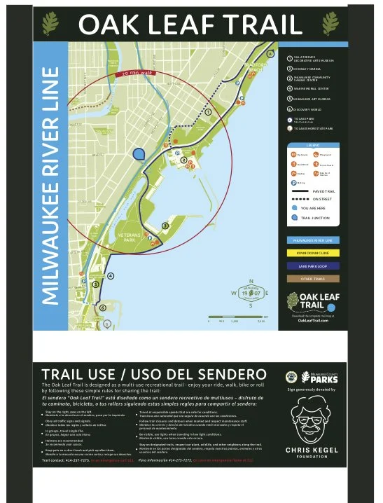
Milwaukee River Line: Following the scenic waterway north
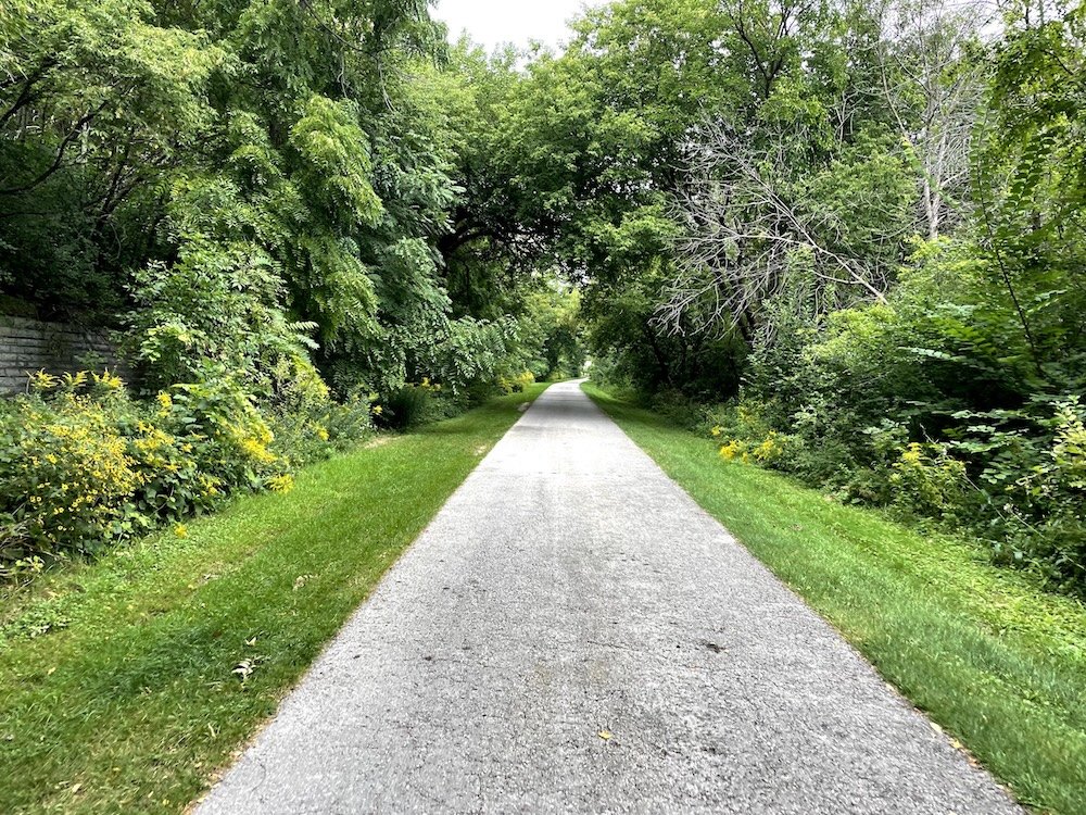
The Milwaukee River Line stretches 14 miles from downtown's Juneau Park to Brown Deer Park, with its Shorewood segment providing the most family-friendly access. Starting at Estabrook Park, this section follows the forested banks of the Milwaukee River northward, creating a peaceful corridor away from city traffic.
Key highlights for families:
Estabrook Park: The crown jewel featuring a popular beer garden, 20-hole disc golf course, dog park, and playground
Urban Ecology Center: Environmental education programs with direct trail access
Gentle terrain: Mostly flat asphalt trail, recently widened from 10 to 12 feet
Natural beauty: Mature hardwood forest canopy with opportunities to spot coyotes, herons, and diverse bird species
Access is easy with free parking at Estabrook Park off N. Wilson Drive, plus additional parking at Hampton Avenue near Picnic Area 6. The trail connects seamlessly to the Zip Line at Estabrook Park, which extends 9 miles north to the Ozaukee Interurban Trail, providing access to Mequon, Grafton, and other North Shore communities.
Lake Line: Eight miles of stunning lakefront views
The Lake Line offers families spectacular Lake Michigan scenery along its 8-mile route from the Milwaukee Art Museum to Lake Park. Following Lincoln Memorial Drive, this segment provides breathtaking skyline views and beach access opportunities.
Family-friendly features:
Bradford Beach: Urban beach with volleyball courts and dining options
Lake Park: Historic Frederick Law Olmsted-designed park with lighthouse and bluff views
Flat, accessible surface: Perfect for strollers, wheelchairs, and beginning cyclists
Veterans Park: 14-acre lagoon with paddle boat rentals and expansive green space
Both segments received major improvements in 2018, including new drainage systems, trail widening, and enhanced stormwater management, making them ideal for families seeking well-maintained, safe recreational experiences.
The Ghost Train: North Shore's magical evening

The Ghost Train in Shorewood
One of the most beloved family attractions along the Oak Leaf Trail system is the Ghost Train at the Capitol Drive bridge in Shorewood. This artistic installation uses thousands of synchronized LED lights and sound effects to recreate the historic "Twin Cities 400" train that operated from 1935-1963.
Schedule and special events:
Winter months (September-March): 7:00 PM northbound, 7:15 PM southbound
Summer months (April-August): 9:00 PM northbound, 9:15 PM southbound
Holiday Express (December): 7:30 PM daily
Circus Train (April-August): Saturdays at 9:30 PM with colorful animal sounds
Night of the Ghost Train (October 31): Costume contest and special programming
The experience is completely free and highly appealing to children, who love the dramatic lights, sound effects, and ground vibrations. Convenient parking is available at nearby Culver's (1325 E Capitol Dr) or Corner Bakery (1305 E Capitol Dr).
Essential North Shore amenities and stops
Shorewood Farmers Market
Located in Estabrook Park at the south end on Active Street, the Shorewood Farmers Market operates Sundays 9:30 AM-1:00 PM from Father's Day through late October. The market accepts SNAP/Quest cards with a Market Match Program and offers fresh produce, prepared foods, and artisanal goods. Trail access is seamless via Oak Leaf Trail connections at Olive Street, Congress Avenue, and Kensington Boulevard.
Sweet treats and dining destinations
BayDQ (Dairy Queen) at 245 E Hampton Ave serves as a convenient trail ice cream destination, operating since 1953 as a family-owned "Chill" format location. The outdoor patio with colorful umbrellas provides the perfect treat stop, specializing in Blizzards, hand-dipped Buster Bars, and classic Dilly Bars.
Additional family dining options include:
Culver's of Shorewood: Butter burgers and frozen custard at 1325 E Capitol Dr
Hubbard Park Lodge: Sunday Lumberjack Brunch and Friday Fish Fries with Milwaukee River views
Crave Cafe: Exceptional burgers with outdoor patio dining
North Shore Boulangerie: Artisanal baked goods and cafe fare
Parks and recreational opportunities
Estabrook Park serves as the recreational hub with its local beer garden, disc golf course, sand volleyball court, and skate park. The park's Milwaukee River access provides kayaking and canoeing opportunities, while the off-leash dog park makes it perfect for pet-owning families.
Atwater Park & Beach in Shorewood offers Lake Michigan beach access with swimming and paddleboarding, directly connected to the trail system. For winter activities, Kletzsch Park in Glendale features a popular sledding hill, archery area, and scenic Milwaukee River waterfall.
Oak Leaf Trail system history

Bublr bike share system helped expand access to trails
The Oak Leaf Trail system represents one of America's most ambitious urban trail networks, originating from the visionary work of Harold "Zip" Morgan in 1939. Morgan, Milwaukee's director of municipal athletics, conceived a 64-mile route encircling Milwaukee County using natural resource corridors—a concept rooted in the youth hostelling movement and 1930s back-to-nature philosophy.
Development milestones shaped the modern system
Foundation years (1939-1970s):
1939: Morgan designed the original 64-mile route
1965: Official recognition by Milwaukee County Parks Department
1967: First paved section (4.5 miles) added in Lake Park with federal funding
1974: Former Chicago & North Western Railroad right-of-way incorporated
1978: Initial paving completed
Modern expansion (1980s-present):
1988: Major 14-mile expansion via Kinnickinnic River Parkway
1996: Renamed "Oak Leaf Trail" (current designation)
2014: Bublr bike share program launched, expanding access to the trail
2018: Trail sections assigned colors and branch names for improved navigation
2020s: Ongoing modernization with $3.9 million in federal funding
The system now encompasses 135 miles of paved multi-use trails serving over 364,000 people annually, with 85% maintained year-round for continued winter use.
Since 2017, the Chris Kegel Foundation has worked with Milwaukee County Parks, and the Wisconsin Bike Fed to create signage to help users navigate the 125 miles of Milwaukee’s Oak Leaf Trail. You can support their efforts by participating in and donating to Chris’ Slow Roll bike ride.
The annual Chris’ Slow Roll helps support signage on the Oak Leaf Trail
Expanding your adventures: Major trail segments throughout Milwaukee County
South Shore Line: The crown jewel for families
The 16-mile South Shore Line ranks as the most popular segment, attracting 230,000+ users annually with its spectacular Lake Michigan shoreline route from Cupertino Park to Bender Park. This segment passes through five parks—Warnimont, Sheridan, Bay View, South Shore, and Grant Park—offering beaches, marinas, and stunning lake views.
Grant Park emerges as the premier family destination, featuring the famous Seven Bridges Trail—a 2-mile loop named one of Wisconsin's best fall hikes. The trail's 10 artistic bridges, stone stairs, and scenic overlooks provide endless exploration opportunities for tweens and teens. Ferch's Beachside Grill offers historic dining with live music, while the beach features volleyball courts and swimming access.
Whitnall Park area: Nature education and botanical beauty
The Root River Line (19 miles) connects to Whitnall Park, a 600-acre recreational complex featuring the Boerner Botanical Gardens with 12 formal gardens and seasonal displays. The Whitnall Loop (3.5 miles) provides an easy family circuit through diverse habitats including woodland, wetland, and prairie areas.
Family attractions include:
Nature Center: Educational programs and wildlife viewing
Whitnall Beer Garden: Family-friendly refreshments
Championship golf course: 18-hole course established in 1932
Disc golf course: Alternative recreation option
Prime birding location: Exceptional during spring and fall migrations
Accessibility and connection points
The trail system connects seamlessly through multiple connector trails:
Bradley Connector (3.3 miles): Links Menomonee, Zip, and Milwaukee River Lines
Drexel Connector (4.5 miles): Connects Oak Creek Line to Root River Line
Beerline Trail: Recent addition connecting Riverwest to Brady Street
Major access points throughout the county include Grant Park, Milwaukee County Sports Complex, Veterans Park, and Brown Deer Park, all offering free parking and essential facilities.
Practical planning
Parking and access strategies
Free parking is available at all major access points, with the largest lots at:
Grant Park (100 E. Hawthorne Ave.): Restrooms, drinking water, concessions
Milwaukee County Sports Complex: Extensive parking with restrooms and concessions
Estabrook Park: Popular North Shore access with beer garden proximity
Veterans Park (1010 N. Lincoln Memorial Drive): Unlimited free parking
Accessibility features include designated accessible spaces, with 14 spaces at the South 60th Street access point, plus ADA-compliant ramps being added system-wide through ongoing modernization projects.
Seasonal timing and year-round activities
Best visiting times vary by season:
October through April: Less crowded conditions ideal for peaceful family rides
Summer: Full amenities available but expect high usage (1,200+ daily users in popular areas)
Fall: Spectacular foliage viewing, particularly along the Seven Bridges Trail
Winter: 85% of trail cleared within 48 hours of snowfall, supporting cross-country skiing
Morning visits provide the most peaceful experiences and optimal wildlife viewing opportunities, while weekend afternoons offer vibrant community atmospheres with diverse trail users.
Activities designed for children
Educational and discovery opportunities
The Oak Leaf Discovery Tour Passport ($5 digital passport) transforms trail exploration into an interactive adventure across 21 parks, featuring clues and hints that engage curious minds. The system connects to Urban Ecology Centers in Washington Park, Riverside Park, and Menomonee Valley, offering environmental education programs.
Nature-based activities include:
Bird watching with specialized trail maps directing users to prime spotting locations
Wildlife observation opportunities for coyotes, herons, and diverse waterfowl
Botanical education at Boerner Botanical Gardens with seasonal displays
Historical exploration at sites like North Point Lighthouse and WPA-era shelter artwork
Active recreation and skill development
The trail system accommodates multiple activities including biking, walking, running, rollerblading, skateboarding, and scootering across varied terrain from flat rural sections to gently rolling hills. Beach access at multiple Lake Michigan locations provides swimming, volleyball, and water sports opportunities.
Connection to regional trails expands adventure possibilities:
Hank Aaron State Trail: Downtown connections
Ozaukee Interurban Trail: 30-mile extension to Sheboygan
Kinnickinnic River Trail: Urban waterway exploration
New Berlin Recreation Trail: Suburban trail extension
Navigation and wayfinding resources
Digital and physical mapping tools
Essential navigation resources include:
TrailLink Interactive Map: Comprehensive online trip planning
Park People App: Oak Leaf Discovery Tour Passport with GPS features
AllTrails App: Individual trail segments with user ratings and conditions
Milwaukee County Bicycle Maps: Available from Wisconsin DOT
Physical resources include brown Oak Leaf Trail signs at key locations, with new wayfinding signage being installed system-wide as part of the modernization project. Mile markers on some sections help with location identification and distance tracking.
Trail etiquette and rules
Basic traffic rules ensure safe, enjoyable experiences:
Stay right while riding or walking with traffic flow
Pass left with clear "On your left" calls or bell signals
Yield rules: Downhill traffic yields to uphill traffic
Group size: Maximum 2 abreast, allowing room to transition to single file
Pet policies require leashes (6 feet maximum) with immediate waste cleanup, while speed control and respect for wildlife maintain the trail's family-friendly atmosphere.
Your gateway to outdoor treasures
The Oak Leaf Trail system transforms Milwaukee County into an accessible outdoor playground where North Shore families can explore everything from scenic lakefront beaches to botanical gardens and historic landmarks. Starting with the familiar Shorewood and east side segments, families discover a world-class trail network that connects diverse communities, natural areas, and recreational opportunities across 135 miles of well-maintained pathways.
This remarkable trail network represents more than transportation infrastructure—it's a community asset that connects neighbors, preserves natural spaces, and creates lasting memories for families throughout Milwaukee County's diverse and vibrant communities.

Plan the perfect family outing to Milwaukee's 2026 Air & Water Show. Get essential tips for parking, viewing spots, noise protection, and navigating crowds at Wisconsin's largest free event.